by Deborah Buehler originally published in Wader Study 130(3)
How do you count something you cannot see? How do you even know what you are missing?
Researchers in conservation and ecology are often faced with these questions because they need to count species and individuals in challenging terrain. Even relatively flat environments like coastal mudflats can be challenging. For example, researchers counting shorebirds from dry land might miss birds tucked in behind elevated ground or just below the horizon of a slanting shoreline. In
this issue of Wader Study, Castenschiold and colleagues report on how they confronted the task of counting birds in such blind zones in the Danish Wadden Sea.
1 They used drones as their “eyes in the sky” and aimed to: (1) predict, map and validate the locations of the blind zones, (2) use drones to peer into blind zones and determine how many birds were missed from the shore, and (3) examine whether differences between species affected the extent of the problem.
Before drones, the only “eyes in the sky” were those of trained researchers, who were flown over mudflats by fearless pilots, and were tasked with counting birds as they flew up when disturbed by the plane. Those who have performed such counts know that it is exhilarating, but also that counting large numbers of birds from the window of a moving plane is rather difficult. Furthermore, flying low and slow as birds fly up beneath and around the aircraft is dangerous. Pilots must sometimes take evasive measures to avoid collisions with larger birds and there is little room for error when flying so low to the ground. Indeed, such flights carry an unfortunately high risk of mortality for the birds and the people.
2 In contrast to planes, drones are small and can fly slowly and safely at lower altitudes. This causes far less disturbance, is safer, and has a much lower cost. Additionally, drone cameras can take pictures, which become a permanent record of the flight.
[caption id="attachment_17695" align="aligncenter" width="330"]

The UAS platform (drone), DJI Phantom 4 Pro (DJI Technology Co. Ltd, Shenzhen, China), used to survey birds occurring in blind zones on the intertidal flats (photo: Johan H. F. Castenschiold).[/caption]
The Wadden Sea is the largest unbroken system of coastal sand and mud flats in the world, and borders the Netherlands, Germany and Denmark.
3 The area is of international importance for migratory shorebirds, which have been monitored there for decades. The researchers worked along the west-facing shore of the Danish Wadden Sea, in the intertidal area where sea and land meet between high and low tides. Their study site encompassed the intertidal area visible from five ground-based vantage points on the Ribe, Rejsby and Ballum seawalls. This site provided high numbers of birds and a topography that made it possible to map blind zones and then use drones to peer within them.
[caption id="attachment_17696" align="aligncenter" width="330"]

The coast of the Danish Wadden Sea, showing how birds standing close to elevated forelands may be hidden from an inland observer (photo: Johan H.F. Castenschiold).[/caption]
Castenschiold and colleagues began by using a visibility simulation tool in Geographic Information System (GIS) software to predict the location of blind zones. This produced a file with elevation measurements plotted on an evenly spaced grid called a raster. Using this raster and the location of the five observation points on the seawall, the researchers could calculate the vertical distance below the observational line of sight for every given point on the mudflats. This was referred to as vertical invisibility (VI).
The next step was to verify the blind zones predicted by simulation with data from the field. To do this, the researchers had to get out onto the mud. They set up dummy birds, approximating the heights of the most common shorebirds in the area (12, 20, 30 and 40 cm tall), along lines of sight between the mudflats and the vantage points. One observer looked out from the seawall through a telescope, while another moved the dummy bird on the mudflat away from the foreland until only the top 5–10 cm of the dummy was visible to the observer. Because of the way line-of-sight works looking down an uneven slope, the tallest dummy birds were set closer to the obstructing foreland and the smallest were set further out onto the mudflat (Figure 2a from the paper
1 is reprinted below for a visualization of how these blind zones work). The blind zone stretched from the edge of the foreland to the 12-cm silhouette.
[caption id="attachment_17697" align="aligncenter" width="330"]

Illustration of the line-of-sight originating from a vantage point on top of the seawall, moving past the edge of the foreland, and onto the intertidal flats (illustration: Johan H.F. Castenschiold).[/caption]
The blind zones mapped using dummy birds in the field closely matched those simulated using the GIS software. Thus, the visibility simulations proved a reliable tool for finding blind zones, and with those areas mapped, the researchers knew where to conduct the drone surveys. They conducted 22 successful flights between 25 September and 15 November 2019, primarily around high tide. The drone was flown within a “green zone” altitude where the minimum flight height did not cause disturbance to the birds and the maximum flight height still allowed for reliable species identification from the pictures and video taken by the onboard camera.
Using images taken from the drones, the researchers manually identified birds from more than 120,000 positions on the mudflat. These data were manually entered into the map produced by the GIS software, which already contained the simulated VIs for positions on the mudflat. Roosting birds were mainly detected within 300–450 m and 600–750 m from the foreland, likely because sandbanks at these distances provided ideal resting areas during the study period. There were 14 species with numbers exceeding 100 individuals present on three or more of the surveyed high tide roosts, and these species became the focal species for the study. With birds identified to species, the researchers could estimate the standing height of most of the birds using the average height for the species. This allowed them to determine whether the bird, detected by the drone, would have been visible to an observer on the seawall. A bird was deemed visible if VI was less than standing height and invisible if VI was greater than standing height.
Because species differ in their size, habitat preference, and preferred position on the mudflat, some were more likely to go undetected than others. Take the example of Bar-tailed Godwits
Limosa lapponica and Eurasian Curlews
Numenius arquata, both large species, but one far more visible from the seawall than the other. Because godwits did not roost in areas affected by blind zones, all of the godwits detected in drone images were also deemed visible from the seawall. In contrast, 90.4% of the curlews detected in drone images were not visible from the seawall because they tended to roost close to the foreland. Dunlins
Calidris alpina are a smaller species with individuals detected by drone both within and outside blind zones and 78.5% deemed not visible from the seawall. These numbers make it clear that a considerable number of birds go undetected during traditional ground-based counts—indeed some 51 to 61% of all roosting birds in this study.
After more than a decade of civilian use, the idea of drones watching like “unblinking eyes in the sky”
4 remains unnerving to some. Indeed, the surveillance of human behaviour has increased with technological advances, and not only from above but also through our devices and data.
5 The ethics of technology use are complicated, but when it comes to drones, Castenschiold and colleagues’ work points to their usefulness as relatively safe and low-cost tools for aerial wildlife observation.
1 Castenschiold, J. H. F., D. Bruhn, C. Pertoldi and T. Bregnballe. 2023.
Monitoring roosting waterbirds: The use of drones to overcome the challenge of hidden individuals in blind zones on intertidal flats.
Wader Study 130(3): 239–253.
2 Sasse, D.B. 2003. Job-related mortality of wildlife workers in the United States, 1937–2000.
Wildlife Society Bulletin 31: 1015–1020.
3 UNESCO World Heritage Centre (2023)
Wadden Sea. Accessed 29 Oct 2023 at:
https://whc.unesco.org/en/list/1314/.
4 Unblinking eyes in the sky (2012)
The Economist [US] 3 Mar 2012: 12. Accessed 31 Oct 2023 at:
http://www.economist.com/node/21548485.
5 Laidler, J. (2019). High tech is watching you (interview with Shoshana Zuboff author of Surveillance Capitalism).
Harvard Gazette. Accessed 21 Nov 2023
https://news.harvard.edu/gazette/story/2019/03/harvard-professor-says-surveillance-capitalism-is-undermining-democracy/
PDF of this article
Posted by Gwenaël Quaintenne on 30 January 2024
by Deborah Buehler originally published in Wader Study 130(3) How do you count something you cannot see? How do you even know what you are missing? Researchers in conservation and ecology are often faced with these questions because they need to count species and individuals in challenging terrain. Even relatively flat environments like coastal mudflats can be challenging. For example, researchers counting shorebirds from dry land might miss birds tucked in behind elevated ground or just below
We are pleased to announce the winning and runner up designs from the second IWSG T-shirt competition - youth edition - are online at our Teemill store! The designs can be found on kids, slim fit and standard t-shirts as well as on a tote bag via the
web pages here and all the colours were chosen by the artists. The winners and runner ups will be getting a copy of one of these t-shirts (or bags) themselves but you can now wear one too!
Many thanks to all who entered the competition, there were lots of great designs and the results were close! In case you didn't see our notices on social media the winning design for the older age category was "Lapwing family" by Réka with a well deserved runner up in "Black-tailed Godwits" by Leni. In the younger age category, "Wuli" by Milou was closely followed by "Hummingbird godwit" by Skye.
Please visit our Teemill website to see the final designs and we hope you are tempted to buy one (or two!):
https://waderstudygroup.teemill.com/collection/iwsg-t-shirt-competition-2023-youth-kids/
Posted by Gwenaël Quaintenne on 18 January 2024
We are pleased to announce the winning and runner up designs from the second IWSG T-shirt competition - youth edition - are online at our Teemill store! The designs can be found on kids, slim fit and standard t-shirts as well as on a tote bag via the web pages here and all the colours were chosen by the artists. The winners and runner ups will be getting a copy of one of these t-shirts (or bags) themselves but you can now wear one too! Many thanks to all who entered the competition, there were
Deadline for IWSG Small Projects Grant fast approaching:
1st December is the last chance to apply for a IWSG Small Projects Grant!
Projects run by IWSG members can be supported with up to 1500 euros. Describe your project, the relevance, the timeline and the budget, and submit it. Then we will read it and get back to you no later than 1st May 2024.
Since 2016, the International Wader Study Group annually funds small projects to support wader studies that otherwise will not go ahead. visit the IWSG Small Projects Grants pages:
https://www.waderstudygroup.org/projects/small-grants/
Regards
IWSG Small Project Grant committee
[caption id="attachment_17579" align="aligncenter" width="330"]

The grant is ideal for supporting small fieldwork projects. Ten grants have been awarded since 2016. Explore them here :
https://www.waderstudygroup.org/projects/small-grants/.[/caption]
Featured image: Field work in Venezuela, ©Carolina Davila.
Posted by Gwenaël Quaintenne on 24 November 2023
Deadline for IWSG Small Projects Grant fast approaching: 1st December is the last chance to apply for a IWSG Small Projects Grant! Projects run by IWSG members can be supported with up to 1500 euros. Describe your project, the relevance, the timeline and the budget, and submit it. Then we will read it and get back to you no later than 1st May 2024. Since 2016, the International Wader Study Group annually funds small projects to support wader studies that otherwise will not go ahead. visit the
The IWSG is happy to announce the winner of IWSG competition for tracking studies which took place during our 2023 annual conference (Sylt, Germany 29/09/23 — 03/10/23).
Dr
Afonso Rocha, from the University of Extremadura, Spain, won
15 GSM MINI 4G Druid Trackers to study "Temperature Exodus" using Black-winged Stilt in the Tagus estuary, Portugal.
read more about the project "Temperature Exodus" of Alfonso Rocha here:
Temperature_Exodus_AR - Afonso Rocha.
[caption id="attachment_17562" align="aligncenter" width="330"]

"
Black-winged-stilt is an excellent model species to investigate the effects of temperature on avian decisions as they breed across a vast range of habitats from freshwater to hypersaline environments" explains Dr Afonso Rocha from the University of Extremadura, Spain.[/caption]
The Price is funded by
Druid Technology Co., Ltd. It includes one year of free data service.
Congrats to Alfonso Rocha!
Featured image: Dr. Alfonso Rocha from the University of Extremadura, Spain.
Posted by Gwenaël Quaintenne on 2 November 2023
The IWSG is happy to announce the winner of IWSG competition for tracking studies which took place during our 2023 annual conference (Sylt, Germany 29/09/23 — 03/10/23). Dr Afonso Rocha, from the University of Extremadura, Spain, won 15 GSM MINI 4G Druid Trackers to study "Temperature Exodus" using Black-winged Stilt in the Tagus estuary, Portugal. read more about the project "Temperature Exodus" of Alfonso Rocha here: Temperature_Exodus_AR - Afonso Rocha. The Price is funded by Druid
IWSG is happy to draw your attention to this new project:
The Global Wader Tracking Data Project.
The GWTDP is intended to work as a directory of tracking studies. Details from the field are recorded: which species, sexes, ages; where and when, using a uniform data format across contributing studies. We encourage users to store their data in a repository such as Movebank, and can help with uploading historical data.
The GWTDP is a new, community-led initiative aiming to become a definitive register of all wader/shorebird tracking projects currently underway or completed.
Read more on the project website
here.
Featured image: Sat-tagged Red Knot ©Rob Buiter
Posted by Gwenaël Quaintenne on 26 September 2023
IWSG is happy to draw your attention to this new project: The Global Wader Tracking Data Project. The GWTDP is intended to work as a directory of tracking studies. Details from the field are recorded: which species, sexes, ages; where and when, using a uniform data format across contributing studies. We encourage users to store their data in a repository such as Movebank, and can help with uploading historical data. The GWTDP is a new, community-led initiative aiming to become a definitive
Following the success of our inaugural t-shirt competition in 2021, and at the request of a number of members we are proud to let you know that we'll be running a new t-shirt competition but this time for our younger members!
We'd like all young waderologists to enter in their best wader designs to be seen on t-shirts and bags on our Teemill website to raise money for supporting the IWSG in its activities (
https://waderstudygroup.teemill.com). There will be two age categories - under 11s and 11-17 year olds and as with the last competition we encourage all original and unique artwork but with the consent of the entrant's parent or guardian.
The winners of the competition will win a t-shirt with their design PLUS a year’s family membership to IWSG whilst the runners up will get a tote bag with their design. All shortlisted designs will be included on our Teemill shop and the winner decided by the attendees at the IWSG conference in Sylt in September 2023
All proceeds from the sale of bags or clothing will be used to support the running of IWSG.
Competition Rules are below and any queries please send them to
membership@waderstudygroup.org.
Competition Rules:
- Open to entrants under the age of 18 who, with their families, are part of the wider wader/shorebird community with permission of a parent or guardian
- Any design will be accepted as long as it has a wader on it, space for the IWSG logo (which can be small) and on a white background
- Meaningful text regarding waders will be considered for inclusion.
- Enter whichever artistic medium suits – pencil and paper, water colours, PowerPoint, Photoshop but you will need to be able to scan the final image cleanly. Lines must be thick enough to see when printed on fabric (~2mm+)
How to enter:
- Parent/guardian to email a scan of the final design with the young person’s first name & the subject line “IWSG T-shirt Comp” to
membership@waderstudygroup.org
- Including a line of consent from the parent/guardian for the child's name to be used
- Up to 3 entries per person are allowed and should be original and unique artwork
- Closing date –
midnight 23:59 GMT 14th September 2023 (submission deadline updated!)
Full Terms can Conditions
IWSG design a tshirt competition_TandC_2023

Posted by Gwenaël Quaintenne on 3 July 2023
Following the success of our inaugural t-shirt competition in 2021, and at the request of a number of members we are proud to let you know that we'll be running a new t-shirt competition but this time for our younger members! We'd like all young waderologists to enter in their best wader designs to be seen on t-shirts and bags on our Teemill website to raise money for supporting the IWSG in its activities (https://waderstudygroup.teemill.com). There will be two age categories - under 11s and
by Deborah Buehler originally published in Wader Study 130(1)
The beach.
For many humans, it means relaxation and recreation. It’s a place to fish, or walk the dog, or sunbathe, or swim. For many shorebird species, the beach is necessary for survival and reproduction. Unfortunately, beaches are not always tranquil. Shorebirds can be attacked by birds of prey or flushed by human beachgoers and their pets. How much does this happen? What causes the disturbance? Can anything be done to reduce the harm?
In this issue of Wader Study, Khwaja and colleagues harness the power of citizen scientist volunteers to address these questions. Using a standardised monitoring protocol, they collected data on the disturbances that shorebirds face when resting on the beaches of Roebuck Bay.
1
Roebuck Bay is a large, tropical embayment in north Western Australia, south of the town of Broome. It is an important non-breeding site on the migration flyway extending from Arctic Russia and North America, along the east coast of Asia, to the southern limits of Australia and New Zealand (the East Asian-Australasian Flyway). Researchers at the Broome Bird Observatory regularly record 29 shorebird species supported by the bay. Because most of these species are migratory and breed in the northern hemisphere, the number of shorebirds in the bay varies greatly between roughly 20,000 individuals through the austral winter (dry season) to roughly 100,000 in the austral summer (wet season). Recently, populations of the migratory species in particular have declined alarmingly within the flyway. Although these declines have been linked to habitat loss in other parts of the flyway (specifically the disappearing mudflats of the Yellow Sea), understanding what happens in Australia improves the chances that the birds will be helped rather than further hindered when they reach the beaches of Roebuck Bay.
The tidal mudflats in Roebuck Bay are extensive, and low spring tides can expose around 175 km
2 of mudflats where shorebirds feed. However, such a high tidal range also means that there is a four-hour period around high tide when the mudflats are totally submerged. During these times, the birds need safe places—called high tide roosts— to rest.
[caption id="attachment_17002" align="aligncenter" width="330"]

Mixed shorebird flock roosting on Roebuck Bay’s northern shores at high tide. (photo: Mattea Taylor)[/caption]
Finding a good high tide roost is not easy. Optimally such sites should be close to the feeding areas and have clear lines of sight to spot approaching danger. In tropical areas like Roebuck Bay, these roosts must also be close to the water during daytime high tides to prevent heat stress. When a good site is found, it makes sense to rest and conserve energy for the duration of high tide, but undisturbed roosting isn’t always possible.
Disturbance is usually defined as the disruption of normal activities caused by an animal’s response to an encounter with an external stimulus. Khwaja and colleagues chose alarm flights—when shorebirds take off steeply and rapidly turn to avoid perceived danger—to quantify disturbance. Models suggest that alarm flights are around three times more energetically costly than ‘commuting’ flights when birds move between areas undisturbed.
2,3 The researchers then enlisted Broome Bird Observatory (BBO) staff and trained volunteers to conduct systematic watches on five beaches in Roebuck Bay. These study sites represented a range of disturbance levels and had been regular roost sites for shorebirds since at least the late 1990s.
Observers worked in pairs when possible, but when volunteer availability was low, experienced bird watchers could work alone. Teams performed watches at each of the five study beaches, simultaneously, sitting close enough to see any shorebirds present, but distant enough not to disturb them. There were two watch days per month from May 2005 until April 2006, and from August 2019 until July 2020, with one watch-day falling on a weekday and the other on a weekend. To gauge how often the birds were disturbed, observers counted all alarm flights made in the four-hour high tide period. They also estimated the average amount of time the birds spent in flight, by performing a short scan every 10 minutes throughout the watch and noting the proportion of birds in flight. The researchers then calculated the average proportion flying per minute and multiplied by the 240 minutes in a four-hour watch. Finally, they tried to determine what caused the alarm flights and recorded details of any visits made by people to the beaches.
[caption id="attachment_17001" align="aligncenter" width="330"]

Volunteers observing shorebirds during a watch at Crab Creek Beach. (photo: Jane Taylor)[/caption]
The observers completed 214 watches over the two years: 96 in 2005–2006, and 118 in 2019–2020. Birds were present on the beach for 196 of the 214 watches and when birds were present, 2020 alarm flights were recorded: 918 in 2005–2006, and 1,102 in 2019–2020. On average the birds were disturbed 2.44 times per hour and the alarm flights usually involved all, or nearly all, of the birds present on the beach. Across all watches, the researchers estimated that each bird spent about 2.86 minutes per hour in flight.
Several factors affected both the number of alarm flights and the estimated time in flight. First, more alarm flights occurred, and birds spent significantly longer inflight, in the dry season (winter) than the wet season (summer). This makes sense because, in the dry season, birds of prey are more abundant in Roebuck Bay, Broome’s population swells with tourists and seasonal workers, and the access road to the northern beaches (study sites) is less likely to flood. Location of the beach was also associated with the number of alarm flights and time spent in flight, but the effect depended on the year of study. This interaction between location and year means that efforts to mitigate disturbance will need to be tailored to the circumstances at individual beaches over time. Finally, more alarm flights were noted when more birds were present on the beach, perhaps because the presence of more individuals increased the likelihood that one of them would detect an actual or perceived threat.
The researchers were able to identify the apparent cause of disturbance for 60% of alarm flights in 2005–2006, and 71% in 2019–2020. Most alarm flights were triggered by birds of prey (raptors) in both years and it is possible that they may have caused even more alarm flights than recorded. In both years, 29 to 40% of alarm flights could not be traced to a stimulus and birds of prey are more likely than other stimuli to have been missed by observers. For example, a brief, silent appearance by a raptor behind a dune is likely to be missed by an observer and can be enough to provoke an alarm flight. Aircraft are noisier and people disturbing shorebirds usually more obvious.
Human visitors were a less frequently identified cause of disturbance than birds of prey, but still accounted for about 20% of the alarm flights with an identified stimulus. Humans were most often seen walking or fishing on the beach, and walkers were more likely to alarm shorebirds (37% or 33 of 90 occasions) than people fishing (21% or 35 of 167 occasions). This is likely because walkers are mobile while fishers are stationary. However, observations from this study also suggest that fishing might have an indirect effect on disturbance because scraps left by human visitors attract birds of prey to beaches.
The researchers suggest various ways to mitigate human-caused disturbance in Roebuck Bay. Examples include: public awareness campaigns about the importance of not disturbing shorebirds on the beach, information for fishers on the importance of not leaving scraps or bycatch on beaches, and even installing floating roost platforms on beaches where human use is already high, to increase available habitat for birds without reducing accessibility to people.
The biggest challenge in this study, and a challenge for anyone attempting to measure the impact of disturbance on wild animals, is that is that researchers can only assume the consequences of an observed behaviour but cannot directly measure those consequences. Khwaja and colleagues were interested in the energetic costs of disturbance on shorebirds but acknowledge that they made no estimate of the true energetic cost of alarm flights, nor was doing so possible with the data they collected. They estimated a response to disturbance and used that as an index of the actual energetic costs. The use of indices is common but requires assumptions and raises the question of whether the exhibited behavior really means what we think it does.
In the case of alarm flights in Roebuck Bay, the assumption is that alarm flights are costly
2 and that when the cost of multiple alarm flights exceeds the cost of a “commuting flight” to a “less disturbed” roost site, the birds will go elsewhere.
3 Khwaja and colleagues estimated that shorebirds exceeded this threshold during the winter at all beaches studied in 2005–2006, and at two of the five beaches in 2019–2020. Yet, some birds clearly continue to roost on highly disturbed beaches in winter. What does it mean when a bird stays put? In many studies, staying is interpreted as low disturbance, but is that always the case? Perhaps the birds also experience disturbance at the nearest alternative roost. Perhaps they stay put and endure the disturbance—which also has costs—because they have nowhere better to go.
4
This study by Khwaja and colleagues is impressive because the energy of volunteers was successfully harnessed in a standardised citizen science monitoring protocol. In this way, the researchers were able collect robust data on shorebird alarm flights and their possible causes, for two full years fourteen years apart. As we move towards summer and beach season in the north, in Roebuck Bay, the austral winter beach season is also beginning. This study is a nice reminder that though we can’t yet directly measure energetic or fitness costs of disturbing shorebirds, we can do our best to minimize our part in it.
1 Khwaja, N., C.J. Hassell, M.J. Taylor, J.A. Taylor, J. Lewis & D.I. Rogers. 2023.
Repeated monitoring suggests shorebirds are disturbed consistently during winter at a globally important roost in tropical Australia.
Wader Study 130(1): 38–51.
2 Nudds, R.L. & D.M. Bryant. 2000.
The energetic costs of short flights in birds.
Journal of Experimental Biology 203: 1561–1572.
3 Rogers, D.I., T. Piersma & C.J. Hassell. 2006.
Roost availability may constrain shorebird distribution: exploring the energetic costs of roosting and disturbance around a tropical bay.
Biological Conservation 133: 225–235.
4 Gill, J.A., K. Norris & W.J. Sutherland. 2001.
Why behavioural responses may not reflect the population consequences of disturbance.
Biological Conservation 97: 265–268.
PDF of this article
Featured image: Bar-tailed Godwit
Limosa lapponica, Orielton Lagoon, Tasmania, Australia. © J. J. Harrison.
Posted by Gwenaël Quaintenne on 5 June 2023
by Deborah Buehler originally published in Wader Study 130(1) The beach. For many humans, it means relaxation and recreation. It’s a place to fish, or walk the dog, or sunbathe, or swim. For many shorebird species, the beach is necessary for survival and reproduction. Unfortunately, beaches are not always tranquil. Shorebirds can be attacked by birds of prey or flushed by human beachgoers and their pets. How much does this happen? What causes the disturbance? Can anything be done to reduce the
The
Doñana National Park in the Guadalquivir basin in southern Spain faces an unprecedented challenge! Despite enjoying all possible levels of legal protection, Doñana National Park and its surrounding natural areas are under severe threat due to decades of (ground)water overexploitation, the effects of which are aggravated by a severe ongoing drought. Adding insult to injury, members of the Andalusian Parliament are pushing a new law proposal to regularize almost 2000ha of illegally irrigated land in the area.
As
international bird migration experts we strongly
oppose the current law proposal, which has already been heavily criticized by experts of Doñana Biological Station, the regional water authority of the Guadalquivir basin, the Spanish Minister of Ecological Transition and Prime Minister, the EU Commission, and UNESCO.
In addition, we are
extremely worried about the impact of the ongoing drought on rice cultivation in Guadalquivir basin. Rice paddies provide vital stop-over and wintering habitat for large concentrations of European waterbirds, for which they are also flooded in winter under an EU-subsidized agri-environment scheme. The drought caused the surface of cultivated rice paddies to drop by >50% in the past two years, and will be close to zero in 2023. This represents a major threat to numerous European waterbird populations.
We therefore take the opportunity to publish an
open letter on UN’s World Migratory Bird Day 2023, 13
th May, under the slogan “
Water: Sustaining Bird Life”, to raise awareness about this pressing issue and requesting UNESCO to list Doñana as ‘World Heritage in Danger’. Representing the international bird migration research community, we stress the need for an ambitious, cross-sectoral plan to preserve the key natural values of Doñana NP and the Guadalquivir basin, and in particular its international role for migrant birds; one of the main reasons for which Doñana is listed as World Heritage by UNESCO.
Wouter V., José A., Jocelyn C., Juan N. & Theunis P.
Open letter is available in five languages:
Featured image: current appearance of the Santa Olalla lagoon, the largest permanent lagoon of Doñana ©EBD-CSIC.
Posted by Gwenaël Quaintenne on 12 May 2023
The Doñana National Park in the Guadalquivir basin in southern Spain faces an unprecedented challenge! Despite enjoying all possible levels of legal protection, Doñana National Park and its surrounding natural areas are under severe threat due to decades of (ground)water overexploitation, the effects of which are aggravated by a severe ongoing drought. Adding insult to injury, members of the Andalusian Parliament are pushing a new law proposal to regularize almost 2000ha of illegally irrigated
The latest IWSG Small Project Grant has been found!
Thomas Lameris' project on
Arctic skuas' possible defensive umbrella exploited by Ruddy Turnstones has been awarded with the IWSG Small Project Grant for the field season 2023.
Many shorebirds nest in loose groups or colonies to form a ‘defensive umbrella’ around their nest. The same may apply to Ruddy Turnstones that often place their nests close to Arctic Skua nests, which can fiercely defend their nest. However, Turnstones are also know for robbing the nests of other species such as gulls. Thomas and colleagues will study these colonies of Ruddy Turnstones and Arctic Skuas to find out who exactly benefits the most from nesting together.
[caption id="attachment_16802" align="aligncenter" width="330"]
Thomas Lameris tracking Red Knot chicks in the field using radio telemetry. (c) NIOZ. Royal Netherlands Institute for Sea Research.[/caption]
Since 2016, the International Wader Study Group annually funds small projects to support shorebird studies that otherwise will not go ahead. visit the IWSG Small Projects Grants pages:
https://www.waderstudygroup.org/projects/small-grants/.
Featured image: Ruddy Turnstone
Arenaria interpres in flight, (c) Jeroen Reneerkens.
Posted by Gwenaël Quaintenne on 10 May 2023
The latest IWSG Small Project Grant has been found! Thomas Lameris' project on Arctic skuas' possible defensive umbrella exploited by Ruddy Turnstones has been awarded with the IWSG Small Project Grant for the field season 2023. Many shorebirds nest in loose groups or colonies to form a ‘defensive umbrella’ around their nest. The same may apply to Ruddy Turnstones that often place their nests close to Arctic Skua nests, which can fiercely defend their nest. However, Turnstones are also know
on behalf of Andreas Rimoldi & Vojtěch Kubelka
Dear fellow shorebird researchers and enthusiasts:
We would like to ask you collaboration for gathering data for new research project, where we aim to analyse the camouflage characteristics of adult incubating shorebirds.
Background and research rationale
Nest predation is a significant cause of avian nest mortality, and in ground-nesting species evading nest detection is an important form of anti-predatory strategy. Egg camouflage has been extensively studied, proving how camouflage predicts survival, when studying shorebirds and nightjars. In the same species, escape distance is possibly related to camouflage on individual scale, of both eggs and adults. Additionally, microhabitat selection and modification on individual level increase the individual camouflage of both nests and adults. We are comparatively investigating adult camouflage in incubating shorebirds, testing the individual camouflage against environmental, life history and geographical variables (e.g. nesting habitat from a broader scale to microhabitat selection, and behavioural variables like mating system and other nest-defense and other anti-predatory behaviour, to provide a detailed insight on how shorebirds rely on and use this anti-predatory strategy.
Since it is already known that ground nesting-birds may suffer increase predation rates in changing landscapes, understanding the role of camouflage and how this influences the nest selection sites and survivability will help design future conservation strategies.
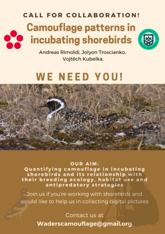 Request for data
We are interested in all shorebird species from all over the world, without the help of the IWSG shorebird community we would not be able to cover the whole diversity of those wonderful animals breeding all over the world!
We are looking for RAW pictures of incubating shorebirds, taken in a side view and centered in a representative portion of the nesting environment, with associated data regarding the observed bird. Every camera that can shoot in RAW is suitable for the project. Unfortunately, pictures recorded with nest-cameras, camera traps or digiscoping would not be suitable for this project.
If you already have some pictures with associated information, please get in touch with us and we will be happy to consider them if they meet the set-up criteria. The project is not only for shorebird researchers. If you know a photographer or birdwatcher that would be interested and able to help, please inform them about the project.
In this project, we will use the dataset gathered up to the end of the year 2023 or start of the year 2024 and we will offer co-authorship in the resulting publication(s) to the collaborators providing suitable photographs used in the analyses.
Thank you very much for sharing this opportunity and if interested please get in touch for details.
Best wishes,
Andreas Rimoldi (
Rimoldi.andreas@yahoo.com,
waderscamouflage@gmail.com) & Vojtěch Kubelka (
kubelkav@gmail.com)
Posted by Gwenaël Quaintenne on 2 May 2023
on behalf of Andreas Rimoldi & Vojtěch Kubelka Dear fellow shorebird researchers and enthusiasts: We would like to ask you collaboration for gathering data for new research project, where we aim to analyse the camouflage characteristics of adult incubating shorebirds. Background and research rationale Nest predation is a significant cause of avian nest mortality, and in ground-nesting species evading nest detection is an important form of anti-predatory strategy. Egg camouflage has been


